Category:Maps of Barbados
Jump to navigation
Jump to search
Countries of North America: Antigua and Barbuda · The Bahamas · Barbados · Belize · Canada · Costa Rica · Cuba · Dominica · Dominican Republic · El Salvador · Grenada · Guatemala · Haiti · Honduras · Jamaica · Mexico · Nicaragua · Panama · Saint Kitts and Nevis · Saint Lucia · Saint Vincent and the Grenadines · Trinidad and Tobago‡ · United States of America‡
Other territories: Anguilla · Bermuda · British Virgin Islands · Cayman Islands · Florida Keys · Greenland · Guadeloupe · Martinique · Montserrat · Puerto Rico · Saint Barthélemy · Saint-Martin · Saint Pierre and Miquelon · Turks and Caicos Islands · United States Virgin Islands
‡: partly located in North America
Wikimedia category | |||||
| Upload media | |||||
| Instance of | |||||
|---|---|---|---|---|---|
| Category combines topics | |||||
 | |||||
Maps of Barbados.
Subcategories
This category has the following 15 subcategories, out of 15 total.
- Blank maps of Barbados (4 F)
*
B
- Maps of borders of Barbados (7 F)
C
E
- Election maps of Barbados (27 F)
F
- Flag maps of Barbados (4 F)
L
- Location maps of Barbados (2 F)
M
O
S
T
Pages in category "Maps of Barbados"
The following 2 pages are in this category, out of 2 total.
Media in category "Maps of Barbados"
The following 53 files are in this category, out of 53 total.
-
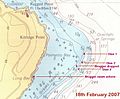
 Access to Cobblers Reef.jpg 2,500 × 2,329; 1.8 MB
-
 Admiralty Chart No 502 Plans in Barbados, Published 1963.jpg 16,364 × 11,158; 21.94 MB
-
 Admiralty Chart No 956 Guadeloupe to Trinidad, Published 1886.jpg 11,283 × 16,450; 28.44 MB
-

-
 Approaches to Bridgetown cropped from Admiralty Chart No 502 Plans in Barbados, Published 1963.jpg 7,975 × 10,100; 12.11 MB
-
 Approaches to Cobblers Reef.jpg 2,500 × 2,329; 1.83 MB
-
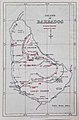
 Barbados - DPLA - 55afdea04e2bde15324f056c41067822.jpg 2,550 × 3,278; 4.98 MB
-
 Barbados DNI Solar-resource-map GlobalSolarAtlas World-Bank-Esmap-Solargis.png 1,842 × 2,617; 709 KB
-
 Barbados GHI Solar-resource-map GlobalSolarAtlas World-Bank-Esmap-Solargis.png 1,842 × 2,617; 706 KB
-
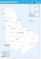
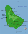
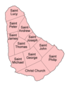 Barbados parishes english.png 500 × 612; 16 KB
-
 Barbados parishes numbered.png 200 × 253; 5 KB
-

-
 Barbados Railway and Police Stations - Waterlow & Sons Limited, London.jpg 714 × 1,081; 181 KB
-
 Barbados, administrative divisions - mk - monochrome.svg 1,205 × 1,339; 132 KB
-
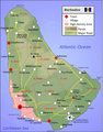
 Barbados-2011.PNG 941 × 1,205; 879 KB
-
 Barbados-2020 englisch.png 943 × 1,205; 859 KB
-
 Barbados-2022 englisch.png 943 × 1,205; 757 KB
-
 Barbados-karte.png 941 × 1,205; 739 KB
-
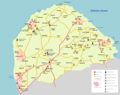
 Barbados2021OSM.png 3,000 × 3,588; 5.62 MB
-
 Coast inside Cobblers Reef.jpg 2,600 × 2,422; 1.84 MB
-
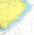
 Coast of South East Barbados.jpg 2,500 × 2,329; 1.67 MB
-
 Coast South East Barbados.jpg 3,850 × 3,587; 2.32 MB
-
 Coastline South East Barbados.jpg 2,500 × 2,329; 1.72 MB
-
 Crchart.jpg 774 × 798; 172 KB
-
 Dive plan.jpg 800 × 663; 93 KB
-
 ECDM 14092017 TC-IRMA overview.pdf 1,754 × 1,239; 853 KB
-
 ECDM 20140219 World Events.pdf 1,625 × 1,125; 624 KB
-
 ECDM 20160929 TC Caribbean.pdf 1,625 × 1,125; 710 KB
-
 ECDM 20161130 Caribbean SW v2.pdf 1,625 × 1,125; 670 KB
-
 ECDM 20170906 IRMA TC UPDATE.pdf 1,754 × 1,239; 805 KB
-
 ECDM 20170911 IRMA HURRICANE.pdf 1,754 × 1,239; 1,017 KB
-
 ECDM 20180717 Caribbean Hurricane-Season.pdf 2,479 × 1,754; 1.38 MB
-
 ECDM 20190827 Caribbean TC DORIAN.pdf 1,625 × 1,125; 674 KB
-
 ECDM 20200724 TC GONZALO.pdf 1,625 × 1,125; 854 KB
-
 ECDM 20210702 TC ELSA.pdf 1,625 × 1,125; 378 KB
-
 ECDM 20210706 TC ELSA update.pdf 1,625 × 1,125; 1.01 MB
-
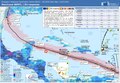 ECDM 20240712 BERYL UCPM.pdf 1,625 × 1,125; 528 KB
-
 ECHO Barbados Editable A4 Portrait.pdf 1,239 × 1,754; 188 KB
-
 ECHO Barbados Editable A4 Portrait.png 794 × 1,123; 179 KB
-
 Holetown.JPG 1,082 × 2,162; 777 KB
-
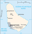 La Barbade carte.png 329 × 352; 23 KB
-
 La Soufriere Ash Plume.jpg 532 × 511; 70 KB
-
 Map of Barbados mk.svg 1,170 × 1,442; 86 KB
-
 Map of Barbados.png 943 × 1,205; 906 KB
-
 Map of Barbados.svg 1,170 × 1,442; 187 KB
-
 Map of Saint Lucy Parish, Barbados.png 3,096 × 2,440; 1.35 MB
-
.svg/120px-Mapa_de_Barbados_(OCHA).svg.png) Mapa de Barbados (OCHA).svg 254 × 254; 369 KB
Mapa de Barbados (OCHA).svg 254 × 254; 369 KB
-
 NOAA Barbados reefs.jpg 1,269 × 1,933; 1.1 MB
-
 PAT - Barbados.gif 750 × 850; 62 KB
-
 South East Barbados Coast.jpg 3,850 × 3,587; 2.4 MB
-
 TTBasin USGS.JPG 544 × 620; 56 KB
-
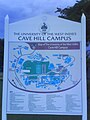 University of the West Indies, Barbados-8.jpg 480 × 640; 66 KB
-
 University of the West Indies, Barbados-9.jpg 640 × 480; 49 KB


.svg)


