File:Divisao-dos-Continentes-America-Europa-Asia-Oceania-Africa-Antardida-Mapa-IBGE-Brasil.svg
Jump to navigation
Jump to search

Size of this PNG preview of this SVG file: 430 × 600 pixels. Other resolutions: 172 × 240 pixels | 344 × 480 pixels | 550 × 768 pixels | 734 × 1,024 pixels | 1,468 × 2,048 pixels | 813 × 1,134 pixels.
Original file (SVG file, nominally 813 × 1,134 pixels, file size: 4.92 MB)
Captions
Captions
Add a one-line explanation of what this file represents
Summary
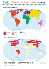
[edit]| Description |
中文:大陆划分(美洲/欧洲/亚洲/大洋洲/非洲/南极洲)-学校地图
English: Division of Continents (The Americas/Europe/Asia/Oceania/Africa/Antarctica) - School Map
हिन्दी: महाद्वीपों का विभाजन (अमेरिका/यूरोप/एशिया/ओशिनिया/अफ्रीका/अंटार्कटिका) - स्कूल का नक्शा
Español: División de continentes (América/Europa/Asia/Oceanía/África/Antártida) - Mapa escolar
العربية: تقسيم القارات (الأمريكتان/أوروبا/آسيا/أستراليا/أفريقيا/القطب الجنوبي) - خريطة مدرسية
বাংলা: মহাদেশগুলির বিভাজন (আমেরিকা/ইউরোপ/এশিয়া/ওশেনিয়া/আফ্রিকা/এন্টার্কটিকা) - স্কুলের মানচিত্র
Português: Divisão dos Continentes (América/Europa/Ásia/Oceania/África/Antártida) - Mapa Escolar
Русский: Разделение континентов (Америка/Европа/Азия/Океания/Африка/Антарктида) - Школьная карта
日本語:大陸の区分(アメリカ/ヨーロッパ/アジア/オセアニア/アフリカ/南極大陸)- 学校地図
Français : Division des continents (Amérique/Europe/Asie/Océanie/Afrique/Antarctique) - Carte scolaire
Українська: Розподіл континентів (Америка/Європа/Азія/Океанія/Африка/Антарктида) - Шкільна карта
Dansk: Opdeling af kontinenter (Amerika/Europa/Asien/Oceanien/Afrika/Antarktis) - Skolekort
Esperanto: Divido de kontinentoj (Ameriko/Eŭropo/Azio/Oceanio/Afriko/Antarkto) - Lerneja mapo |
| Date |
Original Date: 5 October 2018 Date of Conversion to Vector: 21 September 2023 |
| Source | http://geoftp.ibge.gov.br/produtos_educacionais/mapas_tematicos/mapas_do_mundo/politico/continentes.pdf |
| Author | IBGE - Instituto Brasileiro de Geografia e Estatistica (Governo do Brasil), https://mapas.ibge.gov.br/escolares/publico-infantil/mundo.html |
| Permission (Reusing this file) |
This file is licensed under the Creative Commons Attribution-Share Alike 3.0 Unported license.
|
| Other versions | |
| Colours | #000 #fff #231f20 #fffccc #cc5a12 #f1731b #0a83b8 #00acef #32934d #5ec45b #7cb7d6 #e3eff6 #7890ae #1d3258 #0994dc #f1471d #fddd04 #00a650 #7a1d90 #f466ba |
| SVG development |

File history
Click on a date/time to view the file as it appeared at that time.
| Date/Time | Thumbnail | Dimensions | User | Comment | |
|---|---|---|---|---|---|
| current | 19:28, 21 September 2023 | | 813 × 1,134 (4.92 MB) | Zhing'za zï Ïnin (talk | contribs) | {{Information |Description= {{zh|大陆划分(美洲/欧洲/亚洲/大洋洲/非洲/南极洲)-学校地图}} {{en|Division of Continents (América/Europa/Asia/Oceania/Africa/Antartida) - School Map}} {{hi|महाद्वीपों का विभाजन (अमेरिका/यूरोप/एशिया/ओशिनिया/अफ्रीका/अंटार्कटिका) - स्कूल का नक्शा}} {{es|División de continentes (América/Europa/Asia/Oceanía/África/Antártida) - Mapa escolar}} {{ar|تقسيم القارات (الأمريكتان/أوروبا/آسيا/أستراليا/أفريقيا/القطب الجنوبي) - خريطة مدرسية}} {{bn|মহাদেশগুলির বিভাজন (আমেরিকা/ইউরোপ/এশিয়া/ওশেনিয়া/আফ্রিক... |
You cannot overwrite this file.
File usage on Commons
The following 2 pages use this file:
File usage on other wikis
The following other wikis use this file:
- Usage on www.wikidata.org