File:East-Hem 1000bc.jpg
Original file (3,240 × 1,903 pixels, file size: 1.43 MB, MIME type: image/jpeg)
Captions
Captions

|
This historical map image could be re-created using vector graphics as an SVG file. This has several advantages; see Commons:Media for cleanup for more information. If an SVG form of this image is available, please upload it and afterwards replace this template with
{{vector version available|new image name}}.
It is recommended to name the SVG file “East-Hem 1000bc.svg”—then the template Vector version available (or Vva) does not need the new image name parameter. |


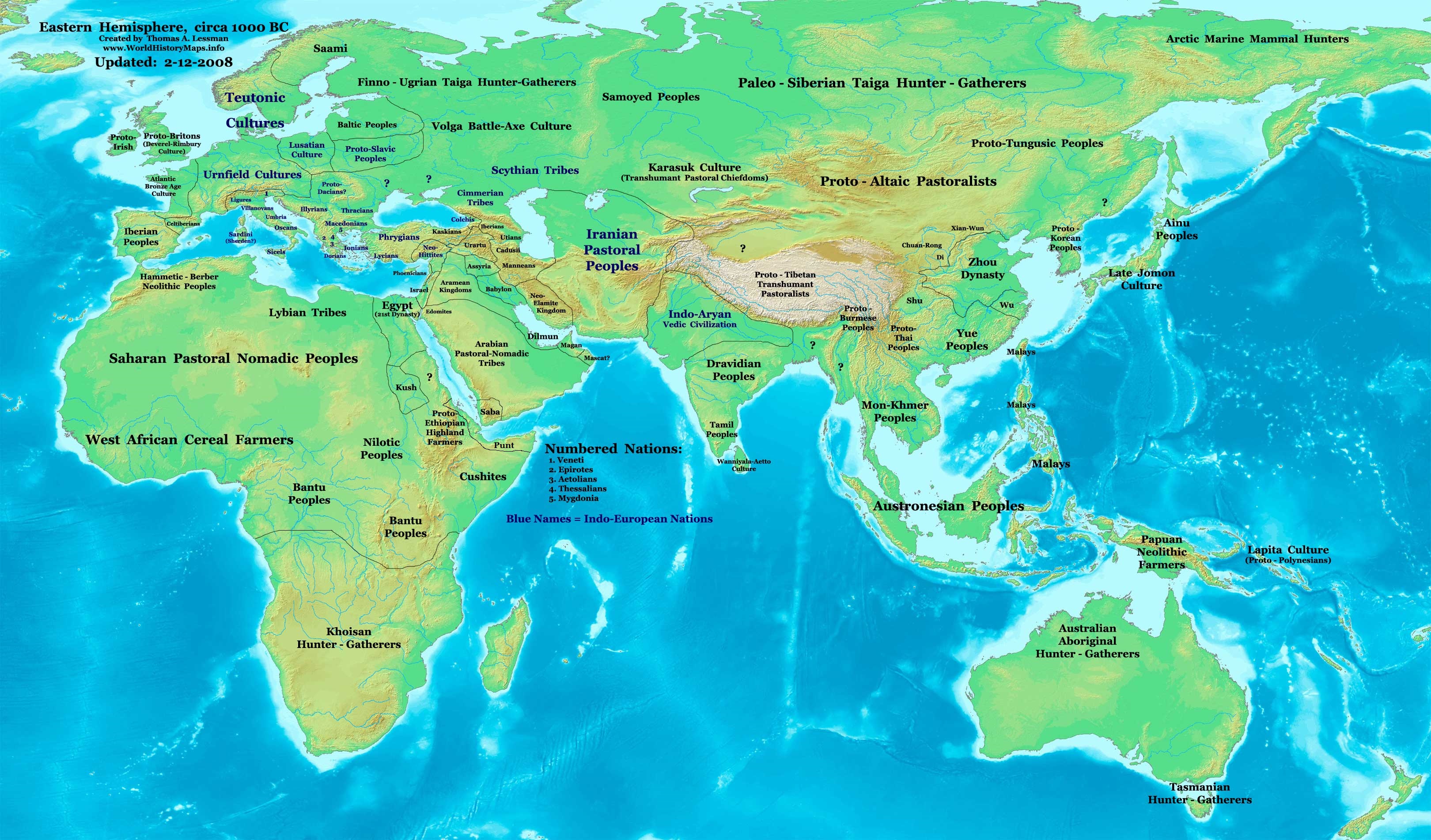
| Description | Eastern Hemisphere in 1000 BC. |
| Source | self-made (For reference information, see below) |
| Author | Thomas Lessman (Contact!) |
| Other versions | see East-Hem_1000bc.jpg file history on Wikipedia. |
Licensing
[edit]- You are free:
- to share – to copy, distribute and transmit the work
- to remix – to adapt the work
- Under the following conditions:
- attribution – You must give appropriate credit, provide a link to the license, and indicate if changes were made. You may do so in any reasonable manner, but not in any way that suggests the licensor endorses you or your use.
- share alike – If you remix, transform, or build upon the material, you must distribute your contributions under the same or compatible license as the original.
Map Summary
[edit]Original Source URL: http://www.thomaslessman.com/History/images/East-Hem_1000bc.jpg.
This map of the Eastern Hemisphere in 1000 BC was created by Thomas Lessman, based on information from the sources listed below. This map is free for educational use (see Permission info above). When using this map, please mention that it is available for free at www.WorldHistoryMaps.info.
Map Source References
[edit]- Remember, sources often conflict with each other. This map is only as accurate as the information that is available to me. To report any errors or to help further this work, please click here, or email Thomas Lessman at talessman@yis.us
References for information contained in this map:
1. Some info derive from the map of the World 1000 BCE, created by User:Briangotts..
2. Zhou (China) borders derive partially from the Huhai.net map of China: 11th to 9th centuries BC.
3. Some information derives from DK Atlas of World History, 2000 edition.
4. Other information is based on various Wikipedia articles and google searches dealing with nations depicted in this map.
Other Maps by Thomas Lessman
[edit]| Maps of the eastern hemisphere showing history
Bold dates are available on Wikimedia or Wikipedia. | ||
| Primeval | ||
| Ancient
|
·| 600 BC | 550 BC | 527 BC | 500 BC |
400 BC | ·| 1 AD | 50 AD | 100 AD | 200 AD | 300 AD | | |
| Medieval |
·| 500 AD | 565 AD | 600 AD | 700 AD | | |
| Modern |
·| 1500 AD | · * For historical maps of the whole world, | |
| Annotations | This image is annotated: View the annotations at Commons |


File history
Click on a date/time to view the file as it appeared at that time.
| Date/Time | Thumbnail | Dimensions | User | Comment | |
|---|---|---|---|---|---|
| current | 11:13, 28 September 2023 | | 3,240 × 1,903 (1.43 MB) | Notradeuussrs (talk | contribs) | added Punt |
| 07:15, 9 May 2008 |  | 3,240 × 1,903 (720 KB) | Talessman (talk | contribs) | {{Information |Description='''Eastern Hemisphere in 1000 BC'''. |Source=self-made (For reference information, see below) |Author=Thomas Lessman (Contact!) |Date= |Location= |Permission={{self|cc-by-sa-3.0}} |othe |
You cannot overwrite this file.
File usage on Commons
The following 3 pages use this file:
.jpg)
File usage on other wikis
The following other wikis use this file:
- Usage on ar.wikipedia.org
- Usage on en.wikipedia.org
- Chaldea
- 1st millennium BC
- 2nd millennium BC
- 10th century BC
- 1000s BC (decade)
- Indo-Iranians
- Late Bronze Age collapse
- User:Talessman/Maps
- User talk:Talessman/Maps
- List of political entities in the 10th century BC
- User:Benjamin Trovato/sandbox
- Transjordan (region)
- User:Falcaorib/Ancient East Hemisphere
- Usage on fr.wikipedia.org
- Usage on gl.wikipedia.org
- Usage on hy.wikipedia.org
- Usage on hyw.wikipedia.org
- Usage on ku.wikipedia.org
- Usage on ro.wikipedia.org
- Usage on sv.wikipedia.org
- Usage on tr.wikipedia.org